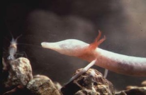
I decided to try and get a head start on my final project. I want to incorporate some sort of conservation site that uses data from the Austintexas.gov site and provides awareness for the endangered Salamander species that are only native to our underground springs.  I combed several databases for data and charts, but ultimately settled for a more reasonable approach at tackling this assignment by trying to make it about one subject. I actually re did all of my charts. The data that you see is not what I initially started out with. My articles are still in their rough draft stage and require more research so that I can be as accurate as possible. I implemented some Jquery in order to get my nav-bar to stick to the top of my page when you scroll down to view my content. You can view my work in progress here.
Fusion Chart:
pros:
I really loved the filtering and easiness it had when it came down to using my csv’s and json’s.
cons:
I really hated trying to implement this into my site. I wasted a lot of time trying to get it to fit right, which sizing it wasn’t the problem. There is something about the iframe element that won’t let me adjust my column widths using the -webkit-column-width property for chrome and the -moz-webkit-column-width property for mozilla.
Highcharts:
pros: I really liked the way it was customizeable once I got them to embed correctly. However they were initially a huge pain in the butt to put in. So I used two just so I could familiarize myself with how they worked. This allowed me to use two separate data sets that I found.
cons: For some reason these bad boys are tough to manipulate. They are incredibly sensitive, but after a few hours of playing with them I got them to work. I probably just have some things wrong with my CSS. I can’t seem to get them to float left.
Charts.js:
Pros: Really cool visualization.
Cons: Haven’t found a practical use for the blind salamanders. Not much is known about how they spend their time.
Google API:
Pros: I enjoyed the user interface, but plotting geographical coordinates has proven more difficult than I thought.
Cons: Coordinates are a huge pain in the butt to plot. I eventually want to plot every location that they surveyed.
If you do not need to waste affordable-papers.net your time attempting to find writers, you should find one now.